
Driving to Alaska. An experience I once dreamed of doing and am now so grateful to have completed. If you are thinking about doing it as well, I am here to help. Here to hopefully answer any questions you have about it, so that you may plan your trip realistically and complete it successfully.
First and Foremost: There are basically only 2 main roads you can take to get there when coming from the lower 48 states.
1. The Alaska Highway (also known as the “Alcan” highway.. short for Alaskan Canadian highway)
2. The Stewart-Cassiar Highway

screenshot of our actual route driven via a location tracker
We personally took one of them while traveling north toward Alaska and the other while traveling south leaving Alaska for a change of scenery. But which route you choose depends on where you are coming from/headed and your preference.
I will first write about general things to know to answer FAQ’S, and then I describe both road routes in detail (mileage, towns to stop at, points of interest, cell service, etc) below that!

Overall things to know:
Gas: You do not need to carry a spare can of gas. Don’t quote me on that, but we personally never came close to running out because there are gas stations in most of the little towns you pass through. Some may be small, outdated gas stations.. but they had gas nonetheless. However, as was suggested to us, we filled up even when we didn’t need gas. If we were at 1/2 tank, we would fill up the tank if passing a gas station. Highly recommend doing this as there ARE very long stretches of road with NOTHING on them so if you wait you may not see another place before you’re empty. The longest stretch of road between 2 towns was 320 miles, but even that stretch had a very small local gas station on it just in case. Also, our van has a diesel engine and the gas stations all had both gasoline & diesel. Lastly, important to note that Canada uses the metric system so their gas prices are in CAD/liter.
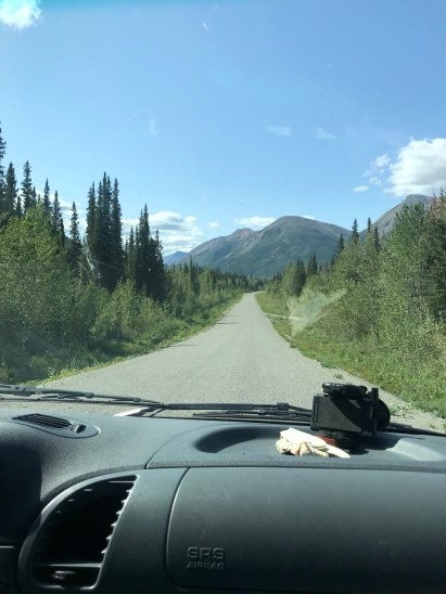
Road Conditions: Despite what you may picture, the roads on the way up are paved and in good condition. At least in British Columbia and Alberta they are. When you get to Alaska and turn off of the main Alaska highway, that is a different story. A lot of roads in Alaska are terrible.. filled with potholes, really bumpy like you’re on a roller coaster, or contain large amounts of stones and rocks. But in general, the roads UP TO Alaska were very well maintained. Also they are very, very, long, ha.

Cell Service: Depends where you are on the road but VERY spotty. I will write in-depth details about where we were able to pick up cell service below.. but expect to not have cell service for majority of your drive. We had both AT&T and Verizon options, and this went for both of them. Although it’s pretty near impossible to get lost, we opted to download our Google Maps when we did have service so that our maps would work offline. We like to know how many miles/how much time we have left and Google Maps is good for that if you download the area maps to use offline.
Wildlife: SO abundant. Probably my favorite part of driving to Alaska was the amount of wildlife we saw every single day, right on the side of the road. You WILL see animals whether you want to or not. Bears (lots of black bears), buffalo, coyote, elk, moose, etc. Please respect them and drive carefully 🙂

Weather/Best time to go: Summertime is definitely the best time to complete this road trip. The 2 main roads ARE usually open all year round (check prior to your trip though).. but a lot of the side roads and smaller roads are CLOSED during winter months. Summer provides the most hours of daylight for the long drive and safest road conditions. We drove up in July and drove back in August and the weather was sunny for the most part. For these reasons, summer is the most popular time of year to do the road trip. But even with it being the most popular time of year, the roads will almost never have any traffic on them 🙂
Safety: Before our trip I really wasn’t scared of much happening. We carry bear spray and other small items for personal protection routinely. However, we happened to be actively driving on the Alaska Highway at the time of the unfortunate Canadian murders in the summer of 2019. These things happen everywhere, all over the world. But here it happened to innocent people who broke down and didn’t have cell service to get help. Because of the lack of cell service (inability to call tow truck or help), and because it would probably take a tow truck or emergency vehicle hours to reach you.. be aware of your surroundings. Let someone who isn’t with you know your plans and where you plan to make it to each night. Have a spare tire in your vehicle and have it’s routine maintenance done before you begin your drive (oil change, etc). If you really want, you can bring a radio to be able to reach someone else nearby on the road. But it is generally an extremely safe area with veryyyy little crime. So you shouldn’t have anything to worry about 🙂 ENJOY YOUR DRIVE. Don’t worry about it. It’s a once in a lifetime opportunity.

realistic depiction of the road conditions of the drive up
Places to Stay: There are plenty of campgrounds for RV’s, tents, and vans in the towns mentioned below. But we were able to boondock in our solar powered van as well. There are some small local lodges for bikers or those without somewhere to stay.. but they can be very few or far between.. so if you do not have an RV or vehicle you sleep in, please know where you will be staying prior to your trip. Again, I will write specific towns on each route below.
Here’s a map of all roads below:
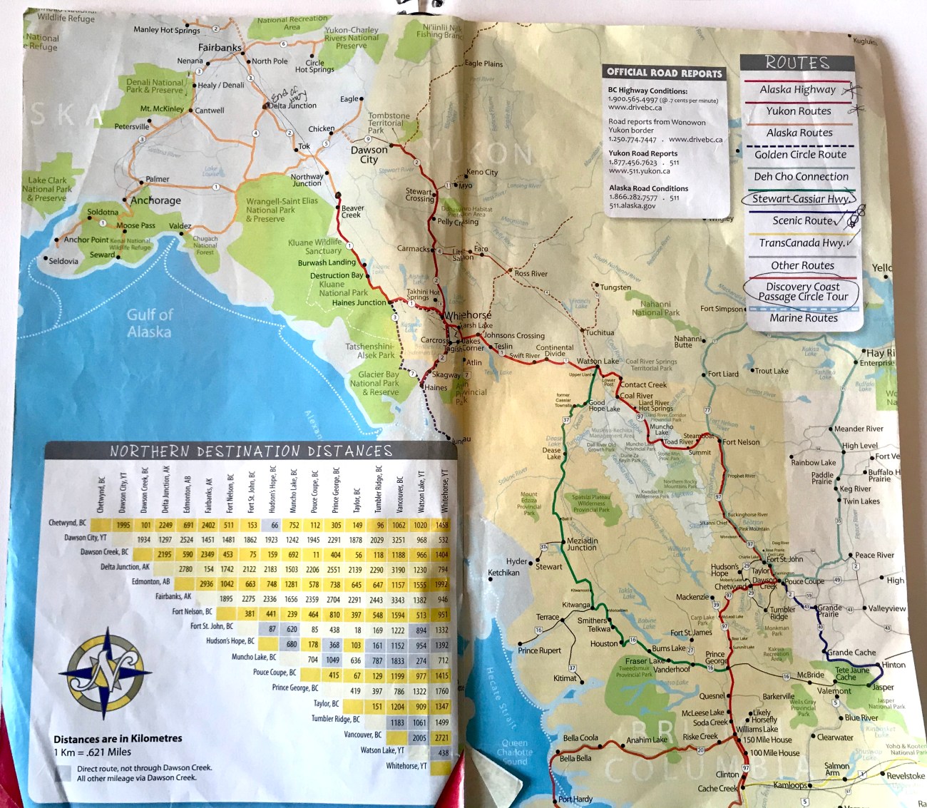
save this photo and zoom in on it for reference! It’s a pamphlet we picked up in a visitor center that we used so sorry about the pen marks on it. Map of the all main roads/main towns in BC/Alberta/Alaska you’ll drive on and stop at. You can see Jasper on the bottom right and Alaska in the top left. Color coded highway key in top right. Also contains phone numbers for road conditions
*Alaska Highway*
Overall Route: Starts in Dawson Creek, BC→ Fort St John→ Fort Nelson→ Watson Lake→ White Horse→ either west to main Alaska ‘Alcan’ Border crossing on Alaska Highway or north to Dawson City then to ‘Northernmost’ Alaska Border crossing
Alaska Highway itself begins in the town of Dawson Creek, British Columbia. It ends at the Delta Junction Visitor Center in Alaska. In total it is 1422 miles long. The Alaskan border is not the end of the Alaska Highway. It is about 1168 miles to the main Alaskan border (“Alcan border”) from Dawson Creek. The Alaska Highway is located further east than the Stewart Cassiar Highway. Multiple towns you drive through will have cell coverage on this route, both AT&T and Verizon. It is red on the map photo I posted above.. and in the closer up map of half the Alaska highway below.

First half of Alaska Highway until Watson Lake in the top left of the map. You can see that you can reach Dawson Creek (official starting point of Alaska Highway) from multiple places (from Jasper like we did, from Prince George, or from the east).
There are many ways to get to the start of the highway in Dawson Creek depending where you are coming from. We personally began our journey from the south from Jasper National Park, BC. So our route from there was Jasper BC→ Highway 40→ Highway 43→ Alaska Highway. We took Highway 40 north from Jasper to Grand Prairie. This part of the drive was about 250 miles taking 4.5 hours. Highway 40 had some potholes, very few cars, and cell service was in and out.. but were able to pick it up about half the time. Grand Prairie is a HUGE town. It has literally everything you could need before starting the long haul remote Alaskan Highway (Walmart, Home Depot, Jiffy Lube, TONS of restaurants, Best Buy, etc). There was obviously gas stations in Grand Prairie, as well as in Grand Cache (before Grand Prairie).
From Grand Prairie you take Highway 43 for 80 miles to Dawson Creek, taking about 1.5 hours. There was cell signal all along Highway 43. Dawson Creek is where the Alaska Highway begins.. so don’t forget to get your photo with the “Mile 0” sign of the highway!! 🙂

Beginning of Alaska Highway in Dawson Creek

official end of Alaska Highway at the Delta Junction
From Dawson Creek you drive the 1168 miles on the Alaskan Highway all the way to Alaska. It is also known as highway #97. Cell service was in and out along the highway, but out more often than in. The road conditions were very good majority of the drive. Here are some towns that you will be able to stop and get gas or spend the night along the Alaska Highway: Fort St John, Fort Nelson, Watson Lake, Whitehorse.
Fort St.John to Fort Nelson: Fort St John is a town with cell service, fast food and gasoline. There is not a lot between Fort St John and the next town of Fort Nelson. There won’t be any cell service for awhile after it either. It is 4 hours and 240 miles between these 2 towns.
Fort Nelson to Watson Lake: Fort Nelson is a small town with food, cell service, gas and a campground. There will not be cell service for about 6.5 hours (320 miles) of driving when you leave Fort Nelson. So make sure you have everything you need, including gas. This part of the drive is VERY remote. However, this stretch of the drive is so scenic and beautiful containing the highest point of the highway. It also contains Laird Hot Springs which is a popular place to stop and relax in natural hot springs for a small fee. It is also when you will officially enter the Yukon Territory for the first time. It is 6.5 hours and 320 miles between these 2 towns.
Watson Lake to White Horse: Watson Lake is a tiny town, but has gasoline, food, and cell service. The sign post forest is a fun quick stop to stretch your legs and look at. Also has cheap campgrounds (we stayed at one without hookups on a lake for about $9) and places to stay the night. No cell service once again when you leave Watson Lake until you reach the outskirts of White Horse. It is about 5 hours and 272 miles between these 2 towns.

The Yukon is very remote, very vast, and relatively flat
White Horse to Alaska: White Horse is a huge town (and capital of the Yukon) with everything you could need for yourself or your vehicle. From there, there are 2 routes you can take into Alaska. 1) The fastest and most popular route would be to continue west on the Alaska Highway to the main Alaska Alcan border. You will have Kluane National Park along side of you on this route which contains some breathtaking mountainous landscape. Or 2) from Whitehorse you can take the longer and more remote route north to Dawson City Yukon and then into the northernmost Alaska border via the Top of the World Highway. HIGHLY recommend this longer route if you have the time to do so!! We took the Dawson City route on our way to Alaska and the Kluane route on our way south leaving Alaska.
On our way north, it took us just under 6 hours to get to Dawson City from Whitehorse. You will pick up cell service in Carsmacks, Pelly Crossing, and Stewart Crossing along the way up. Dawson City is a quaint old gold rush town that is a fun place to spend the night! Definitely do the “toe shot” if you get to Dawson City. It’s also an amazing place to experience the midnight sun!

“Midnight Sun” hotel in Dawson City, if you’re there in summer you WILL experience the midnight sun

rare black fox we saw in Dawson City
From Dawson City you take a free very short (5 minute) ferry across the Yukon River to the start of the Top of the World Highway. It is 110 miles long and NOT paved. There is of course no cell service on that road. However, it has VERY beautiful views, next to ZERO other cars the entire way, and is a once in a lifetime drive. One of the most remote roads I’ve driven in my life. You will enter Alaska at the tiny, scenic, northernmost land border into Alaska on this road too. DO IT!

Top of the World Highway from Dawson City to Alaska

Northernmost Land Border
Once in Alaska, there are so many places to see. I wrote a blog all about must sees in Alaska .. click here to read it.
*Stewart Cassiar Highway*
THE OTHER ROUTE you can take is the Stewart Cassiar Highway. Also known as Highway#37. We took this road on our way south upon leaving Alaska.
From the south it begins in Kitwanga, BC and in the north it ends near Watson Lake, Yukon. It is located further west than the Alaska Highway is. In total it is 450 miles long taking about 10 hours. It does not actually connect to the Alaskan border. It will intersect with the Alaskan Highway near Watson Lake (described above). From Watson Lake to Alaska is another 570 miles. To get to/from the south end in Kitwanga, you take Highway 16 about 300 miles to/from Prince George, BC. The Stewart-Cassiar Highway itself is green in the main map photo above and in the closer up photo of Stewart-Cassiar Highway photo below.

Stewart Cassiar Highway route in Green ending in Watson Lake at the center top of the map, which is where you continue left/west on the Alaska Highway
Overall, there was much less to stop at on this route.. but is convenient for those coming or going more toward the coast, and it is nice to have a different route each way of the long drive. There was 0 cell coverage on the entire Stewart-Cassiar Highway.. All 450 miles of it. I have AT&T on my phone and Verizon hotspot, and neither one picked up cell signal.. not even in the small towns. Go onto this road expecting that.
the very remote Stewart Cassiar Highway
Very small towns that may or may not be open for food/small cabin lodging include Iskut, Tatogga, Bell II, and the Meziadin Junction. You can stop for gas in Dease Lake, Junction 37, and Teslin. We boondocked our entire way back south on the Stewart-Cassiar Highway in our camper van.
No matter which route you take, I assume if you’re driving to Alaska, you love adventure and the wilderness. But this drive is definitely for those that love to be in the wild. We probably saw more wildlife than we did people. I wish I could see that much thriving wildlife everywhere I go in the world. Remember that there are no luxurious amenities for a long stretch of the drive. BUT ENJOY EVERY MOMENT. It is long, but it is the trip of a lifetime. One not many get to do. & One you will remember for the rest of your life!!
For information about Alaska itself, CLICK HERE FOR BEAUTIFUL PLACES IN ALASKA!

Follow me on Instagram @KellyNicoleTravel

Categories: North America, Travel

This is a trip we really wanna make someday so this was a great read for us. Thank you for sharing such awesome info!
LikeLiked by 1 person