 I have been fortunate to have been to 35 out of the 50 US states (so far), including the majority of the national parks/forests/monuments in them… and Glacier National Park is my favorite National Park of all of them. Located in the Northwest corner of Montana along the Canadian border, it is a park FILLED with wildlife and amazing landscape. I visited in the summer of 2019.
Here is basic info you should know about visiting Glacier National park followed by the details of 3 of our favorite day hikes we did (with lots of pictures to help you decide which one to do)!
Basic Info about Glacier National Park:
Cost: $35/vehicle to enter for 7 days, or national parks annual pass accepted. Updated prices and park conditions can be found on their website click here
Campgrounds: Reservations fill up months in advance.. but they have some daily walk-up sites available. To obtain a walk-up site in the summer, be sure to arrive EARLY as they will fill up quickly each day. They cannot officially tell you what time to arrive to get a spot… but I can tell you we ‘walked up’ (drove up) to Many Glacier Campground and the ranger arrived at 7am to allow people to take camp spots for that night. We arrived at about 630am and there was already a line to get a spot. In summer of 2019, we paid $23/night for a campground. I highly recommend Many Glacier for access to multiple different hiking trails. For a complete list of their campgrounds, cabins and info on reservations, visit their website here.
- Backcountry camping requires a permit but is only $7/night.
- Reminder for van lifers/vehicle dwellers like me- you canNOT wild camp/boondock inside national park boundaries*
Wildlife: 71 species of mammals live here and you WILL see some. From grizzly bears to moose, to marmots, it’s an amazing spot for wildlife enthusiasts.

Bears: They’re around. Educate yourself. Respect them. DON’T feed them. DON’T approach them. & If you’ll be doing any sort of hiking, BUY and CARRY BEAR SPRAY… and know how to use it. I hadn’t ever actually bought bear spray in my life before hiking in this area, followed by Canada. We saw multiple bears every day. Luckily, most of them were from the car or from a far distance.. but they’re definitely around. On one of our hikes a park ranger happened to be hiking in front of us and I asked him “have you ever actually had to use your bear spray?” and his response was “oh yes. many times. and IT WORKS”. But hopefully you won’t have to use it.. remember you are in their home. It is exciting to see them, photograph them, watch them in their natural habitat.. but PLEASE follow the rules so they can continue to thrive.
Going-to-the-sun-Road: It is 50 total miles long and the ONLY road that drives THROUGH the park. From the west (Apgar) it is 32 miles to the summit at Logan Pass. Then from Logan Pass it is 18 miles down to the east (St. Mary).
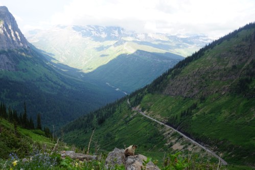
View of Going to the Sun Road from above it
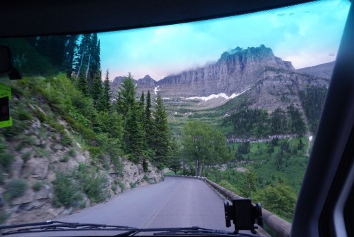
Driving on Going to the Sun Road
DRIVE IT EARLY. We drove on this road twice. Around sunrise we nearly had the road to ourselves.. to pull over and take photos and admire the amazing snow capped mountains without a line of traffic. It was so peaceful and beautiful. When we drove on it in the afternoon there was a literal LINE of traffic and was much harder to stop and enjoy the sights and sounds of nature surrounding us. Logan Pass also fills up early in the day so you will be stuck at the summit waiting for a parking spot if you go in afternoon.
Cell Service: There is none. We went a few days without cell service.. so just be prepared for that.
HIKING
There is an abundance of hiking options in Glacier.. something for everyone. I am going to write details of our 3 favorite hikes we did. They are: Highline Trail, Grinnell Glacier, and Iceberg Lake/Ptarmigan Tunnel:
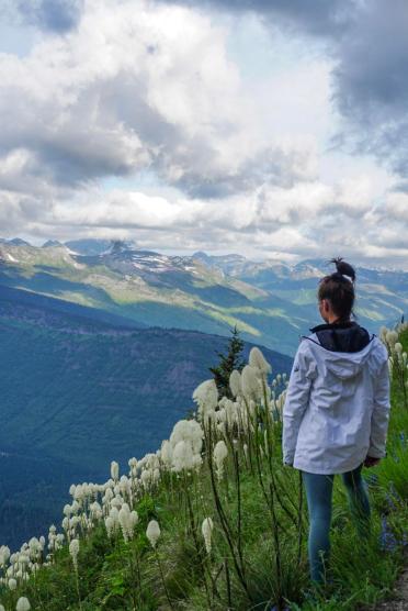
HIGHLINE TRAIL

Highland Trail Views
- Length: 11.5 miles to walk it one way and take shuttle back (or 15 miles out and back)
- Type: One way
- Starting Point/Trailhead: Logan Pass
- Description: Relatively flat and easy majority of the hike, but up high so has amazing views the ENTIRE time. Starting from Logan Pass you will walk high above the park along the “Garden Wall” from east to west toward the Granite Park Chalet. Some areas you will walk along a thin ledge so if you are afraid of heights it may not be for you. The views of the mountain tops all along the trail are stunning. You will be at some of the highest points in the park.. and walking over large patches of snow.

About halfway through Highline Trail
- It is 7.5 miles from Logan Pass to the Chalet. The Chalet is a good place to stop and eat lunch and there are also bathrooms there. There is no hot foot/drinks there.. bring your own. From the Chalet you have 2 options to get back to your starting point. You can choose to walk the 7.5 miles back the way you came to Logan Pass OR walk 4 miles down the mountain from the Chalet (steep and through the woods) to Going-to-the-Sun-Road near “The Loop”. A free shuttle that runs throughout the day stops at The Loop and can drive you from there back to Logan Pass. We prefer to not re-trace our steps so chose the second option. It was nice to get to drive along the road again as well. We saw multiple white mountain goats, bighorn sheep, and 1 bear form a distance during our hike. We started our hike at 7am and finished at 1230pm with a 15 minute lunch break included. So took us 5.5 hours for 11.5 miles. One more thing to note is there are other trails that connect to this one if you want to add them on. For example, the Glacier Lookout (high overlook of Grinnell Glacier area) is an extra 1.2 miles total (.6 each way but with high elevation gain in that short amount).
toward beginning of Highline Trail

beginning of Highline Trail along the Garden Wall

In middle of Highline Trail
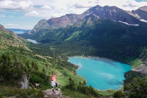
GRINNELL GLACIER TRAIL

Grinnell Glacier
- Length: 11.5 miles round trip (but can make much shorter by turning around sooner at various viewpoints)
- Type: out and back
- Starting Point/Trailhead: Many Glacier
- Description: My favorite trail we did. We hiked all the way up to the Glacial Lagoon itself, which is 5.7 miles one way. The first 2 miles were relatively flat, and the last 3.7 uphill. In early July, some of the trail was still covered in sketchy patches of snow that we had to hike over, as well as under 1 waterfall. Because of this, and other reasons, many people turned around at various points before the top. You will pass and have views of 3 different lakes along the way: Swiftcurrent, Josephine, and Lower Grinnell. You can just walk around or to any of these if you are looking for a quick easy walk. It is 3.4 miles to hike to the furthest lake of those 3, Lower Grinnell Lake, which doesn’t require hiking up most of the tough uphill hike for those that can’t do that. & For the EASIEST option you can even take a boat across Lake Josephine to Lower Grinnell Lake access.
views of all 3 lakes: Swiftcurrent, Josephine, Lower Grinnell

standing above Lower Grinnell Lake
But the best views are definitely past Lower Grinnell so I highly recommend going up the mountain to Grinnell Glacier itself!! One of my favorite spots I’ve ever sat in my life. It took us 2 hours and 40 mins to get to the top and 2 hours and 20 minutes to get back down. So 5 hours of hiking total not including lunch/break at the Glacier.

had to walk across that big patch of icy snow.. was steep so please only walk if comfortable and confident on your feet!

the beautiful glacial water at the top
ICEBERG LAKE/PTARMIGAN TUNNEL TRAIL

arriving at Iceberg Lake
- Length: 9.8 miles RT to Iceberg Lake alone, 9.2 miles RT to Ptarmigan Tunnel alone, OR combine both into one hike for 14.6 miles total RT (which is what we did)
- Type: Out and Back
- Starting Point/Trailhead: Many Glacier behind Swiftcurrent Inn Cabins
- Description: I am grouping these 2 hikes together because they start at the same point and the first 2.1 miles of them are the EXACT same trail. Ptarmigan Tunnel trail is a side trail off of the Iceberg Lake Trail. We hiked to Iceberg Lake first and then veered off onto the Ptarmigan Tunnel trail on our way back. You could do this in the opposite order as well. The Iceberg Lake trail is relatively flat the whole way there and done by many families. It is 4.9 miles from the trailhead to Iceberg Lake one way making it 9.8 miles round trip if you only do the Iceberg Lake trail. It took us 2 hours to get to the lake.

moose we saw on Iceberg Lake Trail
On our way back from the lake, we re-traced our steps 2.8 miles until we got to the Ptarmigan Tunnel trail on the left (if you’re coming from the starting point trailhead, the tunnel trail will be on your right). It is only 2.5 miles to the Tunnel from this turnoff but it is entirely uphill the entire 2.5 miles. This trail is not for beginners or those unable to walk uphill for extended periods of time. It is uphill through the woods for a mile and 1/2 or so of it, and then goes up steep switchbacks on the side of a mountain for the last mile. At the top of the switchbacks there’s a literal tunnel through the mountain. AND THE VIEWS AT THE TOP ARE SO WORTH IT. The views on each side of the tunnel are completely different from one another. On the far side the mountains are red rock and so colorful and different than the rest of the park. Highly recommend pushing yourself to add the extra 5 miles to this spot. If you go early in the season when there is still snow, the trail and tunnel may be closed with no access through the tunnel.. so be sure to check trail conditions before hiking there.

views one side of the Ptarmigan Tunnel

views from the other side of the Ptarmigan Tunnel

Ptarmigan Tunnel
Other hikes: Hidden Lake is a popular quick and easy walk from Logan Pass. Lake MacDonald is a popular but beautiful lake with good photo ops because of the clear water, Swiftcurrent Pass and Piegan Pass are for those who desire a longer hiking adventure. There is something for everyone.. but this park will be best enjoyed by nature and wildlife enthusiasts.
Hope this helps! Feel free to message me on Instagram @KellyNicoleTravel or shoot me an email at KellyNicoleTravel@gmail.com with any questions you may have! And dont forget to follow along with our travels @KellyNicoleTravel. Love ya’ll, happy hiking!
Categories: North America, Travel
