Despite it’s small size, the island of Puerto Rico contains a very diverse amount of nature. Most people tend to flock toward the blue water beaches, breathtaking coastlines, and big cities. However, if you prefer to be a bit more adventurous, you should DEFINITELY head toward El Yunque Rainforest for some hiking. Or if you aren’t into hiking, you should still get there to see the fresh, thick, lush greenery that is in El Yunque! In my opinion, it is the prettiest part of Puerto Rico. See the lusciousness in the 2 photos below ↓ ↓

There are multiple hikes you can complete in El Yunque. Of course I wanted to (and did) complete them all, so I am here to tell you the details of the hikes so you can determine which one(s) is best for you!! They are listed below in this order: La Coca Falls, La Mina Falls, Juan Diego Falls, Mount Britton, and El Yunque’s Peak. (Just in case you want to scroll to a particular one you are looking for ♥ )
What you need to know: There is only 1 main road inside of Yunque. That road is called PR191. You can easily locate the different hikes and points of interest by the km number markers on that road. The gates for PR191 are open daily from 7:30am-6:00pm. There is no entrance fee… all FREE.
- 1. La Coca Falls

La Coca Falls
If you are there just for the views and the scenery, this waterfall is perfect for you. NO hiking necessary. It’s literally on the side of PR 191. There is a small parking lot around km 8.1 that you park in and the waterfall is right next to it. You can’t miss it. It is an 85 foot high waterfall on a large rock formation. This spot is likely to be filled with people. Get there early in the AM to avoid that (I will say that for every hike though).
- 2. La Mina Falls

La Mina Falls
La Mina Falls is the most “touristy” and popular of all places in El Yunque. It is typically filled with so many people. I went early in the morning (around 8:30am) and there was only 2 other people there (go EARLY). I was the only car in the parking lot when I got there, but when I drove by mid afternoon the lot was overflowing onto the main road with cars. It is popular because you are able to swim in the water at the base of the falls. No bathroom or changing room is at the waterfall itself, so be sure to prepare yourself for what you want to do prior to the start of your walk.
There are 2 paths to get to La Mina. They are Big Tree Trail (km 10.4) & La Mina Trail (km 12). They are both about the same length, but La Mina Trail is slightly shorter. Although it is the most popular waterfall, that does mean it is “easy” to get to. The trail is very narrow and filled with many stairs.

I personally accessed it by La Mina Trail. It starts directly behind Palo Colorado visitors center at km12. In the beginning of the trail there are many “forks in the road” because there are many pavilions to picnic in. Be sure to always stay on the cobblestone path and to follow La Mina River. The entire trail is paved and follows the beautiful water until the waterfall. After you reach the river, if at any point you cannot see or hear it, you probably turned the wrong way. But the trail is paved, so in general it is very hard to get lost. The entire way there is downhill. Keep this in mind as that obviously makes the way back all uphill. See the pictures below. The left picture shows the river you follow and a few of the many stairs you will climb. The right picture shows the narrow cobblestone path that you walk on when not on stairs.


Walking briskly, it took me about 20 minutes to get to the waterfall from the parking lot (I’d say on average it takes about 30 minutes). It took me about 5 minutes longer to get back because of it being uphill. If you take your time, there is so much beautiful scenery to take in as you walk. You will see many smaller waterfalls in the river along your walk.

Smaller falls that you see on way to La Mina Falls
- 3. Juan Diego Falls

Juan Diego Falls
Juan Diego Falls is called “El Yunque’s best kept secret”.. and for good reason. It is for those who like the road less traveled and push themselves out of their comfort zones. Not many people complete this hike, and it is one of the only unpaved trails in all of Yunque. You begin by parking your car near km 9.8 on PR191. From there you will walk to the river on the right hand side of the road. You may see many people walking toward that river because there is another waterfall (that many think is Juan Diego falls) a very short walk from the road.
If you want to reach the real Juan Diego, veer off to the RIGHT hand side of that large waterfall to begin the hike. I started off by following one other family on the trail, but they soon gave up and turned back. After that I only saw ONE couple the entire time I hiked this. The beginning of the “off beaten” path is filled mainly with large tree roots that are relatively easy to walk up (pictured below).

the beginning of the trail
After the tree roots, it will turn into a less clear trail. You will pass a few more waterfalls in the river along the way. You will step through brush, climb up roots and boulders, step in muddy areas, and might even second guess why you got yourself into this hike. BUT, it is so worth it. I thought I was lost but kept moving forward and eventually found it. It was so rewarding AND I had the entire waterfall to myself the whole time I was there. Pictured below was a more questionable part of the path where I had to guess if I was headed the right direction.

part of the trail that was difficult to determine which way to go
****Here are a few pointers to keep you on the right “path” to Juan Diego:****
- The ground is obviously “stepped on” in a lot of the parts (especially in the beginning), making it obvious which way to go.
- In the places that aren’t so obvious, past hikers have marked trees with different color tape. If you see any trees with orange, black, or green tape around them.. you are headed the right way. This tape helped me significantly toward the end of the hike. I could see the waterfall, but couldn’t figure out how to get down to it. But alas, I then saw a tree with tape on it which led me down over big boulders.
- The most helpful way to not get yourself lost is to never veer far from the river! The beginning of the hike follows the right side above the river. At one point you will walk down and have to cross the river by stepping on rocks. The final part of the hike is climbing up along the left side of the river. If at any point you cannot at least hear the river, you have gone the wrong way. This is perhaps the most helpful point.
When you have reached the waterfall pictured below, pat yourself on the back as you have done it!! Relax and swim in the bottom of it. Take in the beautiful scenery, hear nothing but birds and bugs and the falling water, with no chatter of other people!

Juan Diego Falls
Be careful getting into the water as 1. the rocks are slippery and 2. it falls off quickly to deep water that you probably cannot stand in (I couldn’t stand much past that rock pile). The entire hike took me about an hour on the way there, and 30 minutes on the way back (you will be more confident with which way to go)… Enjoy! 🙂
- 4. Mount Britton Lookout Tower
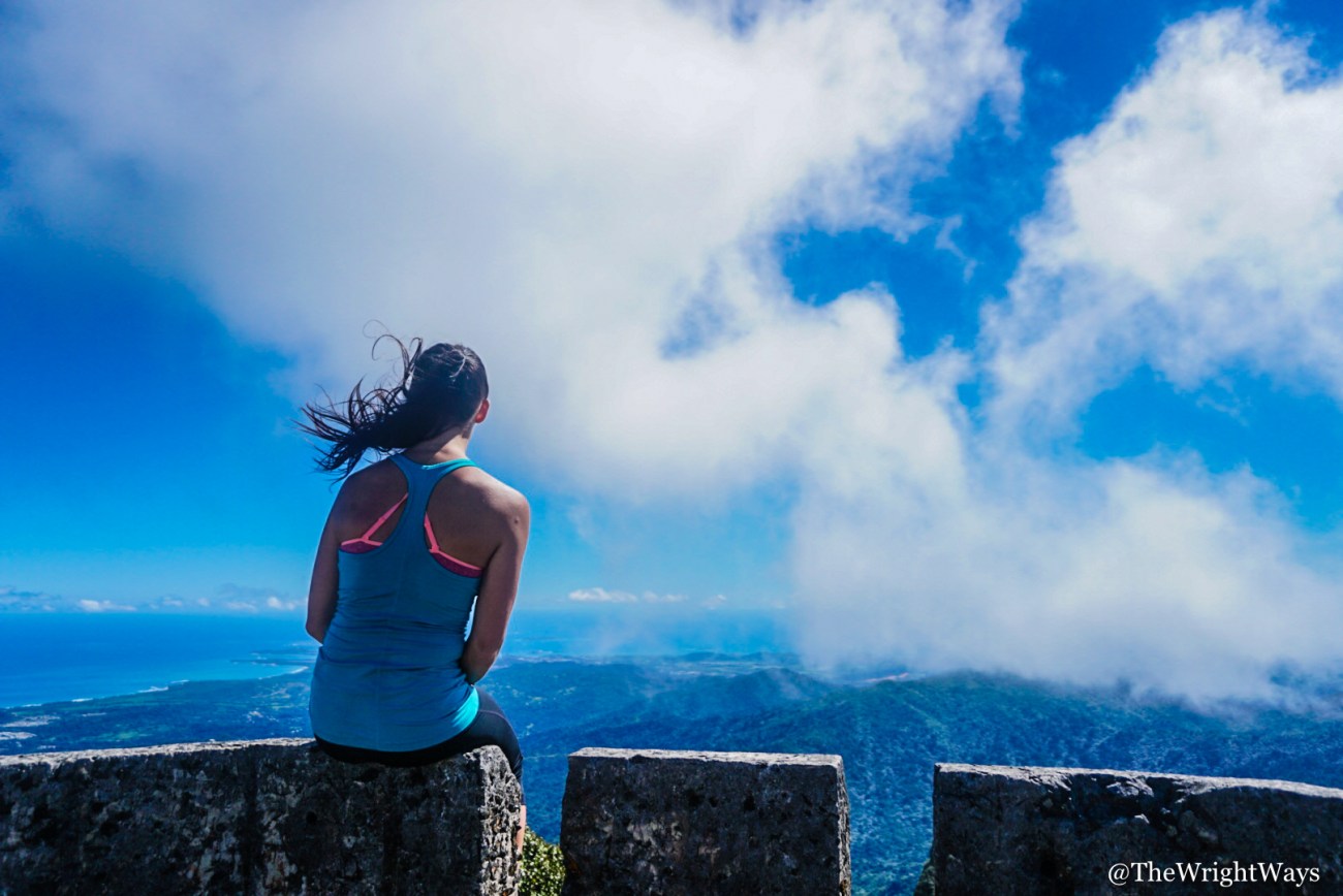
sitting on top of Mount Britton
The first 3 hikes in this post were all to waterfalls. The last 2 hikes in the post are to high points and lookouts. The first one being to Mount Britton Lookout tower. To begin, take PR191 to km 12.7 and turn right onto PR9938. You will see the trailhead on the right hand side of 9938.. park on the lefthand side of the road just after the trailhead.
The entire hike up to Mount Britton is uphill, but very very easy to follow. The whole trail is a paved narrow cobblestone trail. The uphill part will challenge your stamina, but I saw many children completing this hike, so you can do it!


You will follow the narrow path until it comes to an end at a paved roadway called road 10. This roadway you can either go left and walk down the road back to PR191, or go right to continue walking upward to reach Mount Britton. After walking about 5 minutes up on this roadway (no cars allowed on it.. safe to walk on), you will turn right when you see the sign for Mount Britton. It is a very quick walk from that sign to the tower itself.

Mount Britton Tower
The views from the top of Mount Britton are beautiful. It has an elevation of about 3087 feet. You will be in line with the clouds and if you are there on a clear day, you can see the ocean and coastlines from it (even though you are so far inland). The hike is just under 1 mile one way, and will take you 40-45 minutes-ish one way. The way down will be all downhill back to your car.

standing on the top of Mount Britton Tower
- 5. Peak of El Yunque (highest point)
The peak of El Yunque is the highest point in El Yunque. It is 100% worth the uphill hike to get there. And if you hike to Mount Britton, you MUST do the extra 30 minutes to reach it. You can reach the peak by following the exact same trail mentioned above to Mount Britton (read above).

The only difference is once you reach road 10, and turn right to continue up hill… you then turn left at the Mount Britton sign (instead of going right to the Britton tower) and walk up Road 10 all the way until it ends. This makes the total hike time about 1 hour and 15 minutes to 1 and 1/2 hours on the way up. It is all uphill, so be prepared for burning thighs. It is nearly impossible to get lost if you take road 10 up there as you walk on a wide road the entire way (after the narrow path from road 9938 mentioned in Britton hike).

The observation tower on El Yunque’s peak
There is an observation tower at the peak of the trail. You can climb to the top of it for the best views. On a clear day, you can see the northern Coast from Old San Juan all the way to halfway down the east coast, as well as the top of the rainforest you just hiked. VIEW VIEWS VIEWS. I recommend getting there in the morning hours for higher chances of clear skies. I was there around 9:30 in the morning and the skies were blue as can be.
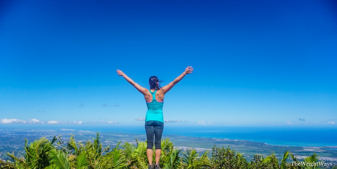
views from the peak of El Yunque
There you have it. 5 places in El Yunque that you cannot miss!! Get your butts outside and start living! If you have any specific questions about these hikes or El Yunque in general, don’t hesitate to email me at KellyNicoleTravel@gmail.com or message me on my instagram account! (@kellynicoletravel)
Happy Travels!
-Kelly
Follow me on Instagram & Twitter for more awesome stuff!!
Categories: Caribbean, North America, Travel
